
Nordkop Mountain Introduce
For New Yorkers who love to hit the trails and seek out invigorating challenges with spectacular rewards, the Ramapo Mountains offer a wealth of opportunities right in our backyard. Among these, Nordkop Mountain stands out as a hidden gem, providing a rigorous climb and breathtaking panoramic views that make every step worth the effort. While it might be a little "tricky to find" for first-timers, its reputation as "the best place to hike in Suffern" and a prime spot for rock climbing within a 40-mile radius speaks volumes about its allure.
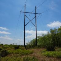
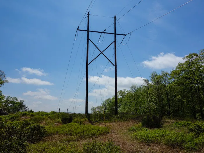
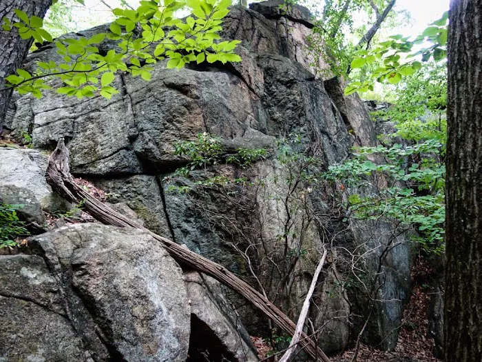
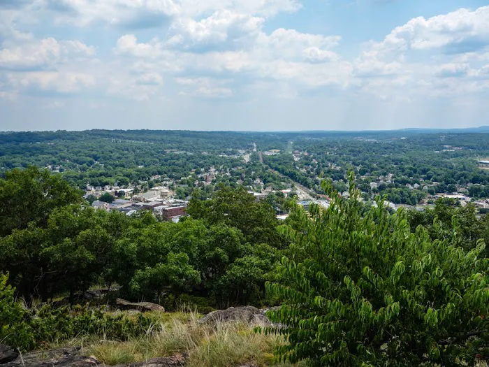
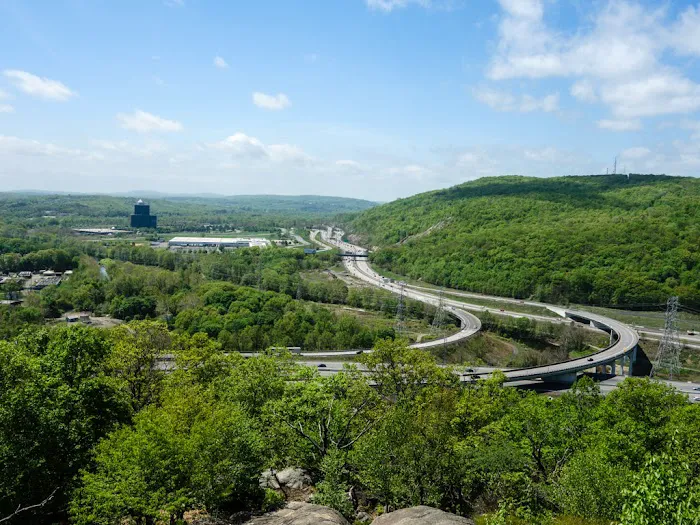
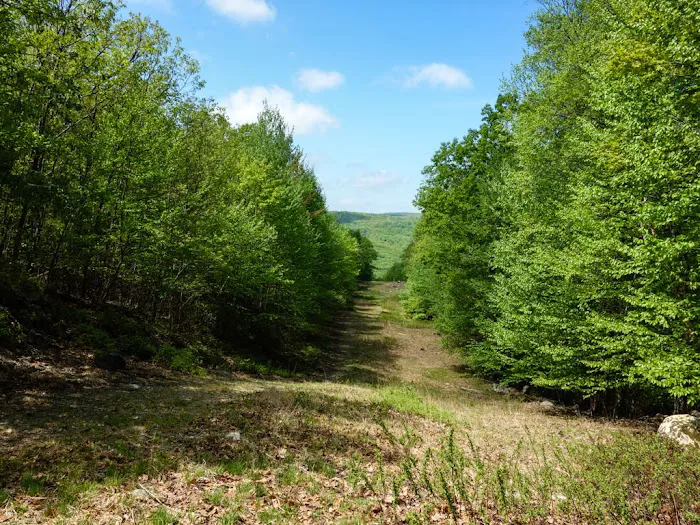
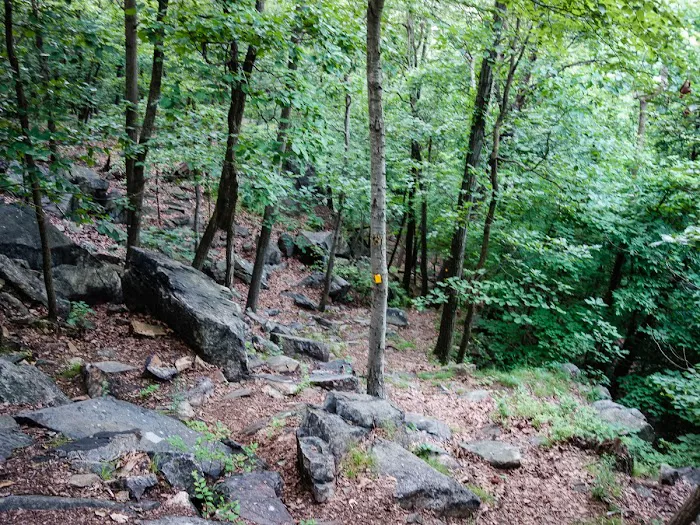
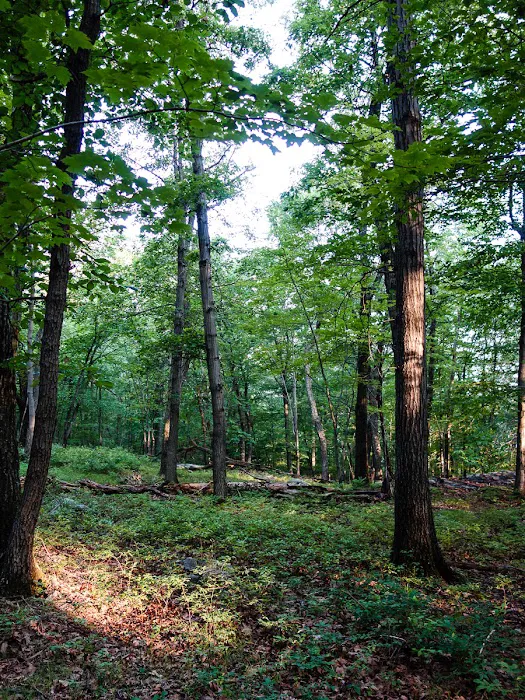
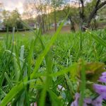
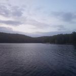
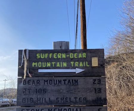
Nordkop Mountain isn't just another hill; it's a prominent feature near the southwestern end of the iconic Suffern-Bear Mountain Trail (marked with distinctive yellow blazes). This challenging ascent, though less than a mile in length, boasts a significant 500-foot elevation gain, making it a perfect quick-but-strenuous workout for those looking to test their limits or simply enjoy an invigorating burst of nature. From its exposed rock summit, hikers are treated to expansive vistas of Suffern, the surrounding hills, and even distant highways, creating a unique blend of wilderness beauty and regional perspective.
This article aims to provide a clear, engaging, and informative guide to Nordkop Mountain, highlighting its precise location, remarkably accessible public transport options, the nature of its trails, and the unique features that make it a compelling destination for local New York hikers and climbers. We'll also provide essential advice for planning your trip, including safety considerations and where to find the best trail resources, ensuring your adventure to Nordkop is both rewarding and safe.
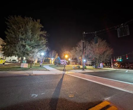
Nordkop Mountain is prominently located near the southwestern end of the Suffern-Bear Mountain Trail (distinguished by its yellow markers). While the given address, "Airmont, NY 10901, USA," broadly covers the area, the specific trailhead for Nordkop is situated directly on Orange Avenue (Route 59) in Suffern, NY. This strategic placement makes it exceptionally accessible for New Yorkers relying on various modes of transportation.
For those traveling by car, Nordkop Mountain is easily reached via major routes. From the New York City area, you would typically take the New York State Thruway (I-87) North to Exit 15, then connect to Route 17 North to Suffern, or take I-287 West to the Suffern exit onto Route 59. Once on Orange Avenue (Route 59), the trailhead will be identifiable, though as reviews mention, there isn't a direct sign advertising where to go specifically for Nordkop. However, there is ample "commuter lot parking within a short walk" of the trailhead, compensating for the lack of dedicated trailhead parking. It's always advisable to use these official lots rather than parking directly on the street to avoid issues.
A significant advantage for Nordkop Mountain's accessibility is its proximity to public transportation. The trailhead is a mere "10 min walk from Suffern station," which is served by Metro-North trains (Port Jervis Line), connecting directly from Secaucus Junction, NJ (with connections from Penn Station NYC). Additionally, it's only a "5 min walk from a commuter lot parking" used by Shortline Bus services, offering another convenient option for those coming from different parts of the tri-state area. This exceptional public transport access makes Nordkop Mountain a prime destination for city dwellers seeking a quick escape to the trails without needing a car.
Due to its exposed nature at the summit, it is "not recommended to hike there during strong winds or thunderstorms." Furthermore, "rain, snow, or fallen leaves provide an added difficulty due to slippery rocks." Hikers should always check weather conditions before heading out and wear appropriate footwear for rocky, potentially slippery terrain.
- Access to the Suffern-Bear Mountain Trail for hiking.
- Opportunity for rock climbing and bouldering (unregulated, users should be experienced and prepared).
- Stunning panoramic views for observation and photography.
- Starting point for longer multi-day hikes into Harriman State Park (with nearby shelters for overnight stays).
- Opportunities for trail running due to its challenging incline.
- Public access via nearby commuter parking lots and public transportation.
- Natural setting for wildlife viewing and bird watching.
- Excellent Panoramic Views: The summit of Nordkop Mountain offers "excellent views of Suffern, nearby hills and highways." This open, exposed rock top provides a vast vista, making the challenging ascent incredibly rewarding.
- Gateway to Suffern-Bear Mountain Trail: Nordkop is situated at the southwestern end of the yellow-blazed Suffern-Bear Mountain Trail. This trail extends for about 25 miles, offering options for various hike lengths, from short out-and-back excursions to ambitious overnight treks.
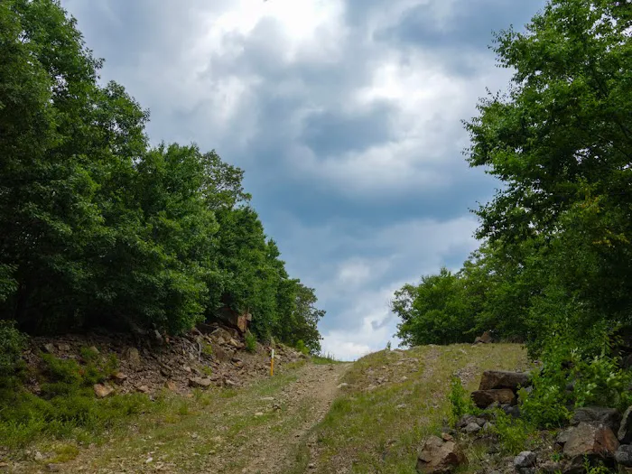
- Challenging, Quick Ascent: Described as a "moderate-to-strenuous" climb, the ascent to Nordkop's summit is less than a mile with approximately a 500-foot elevation gain. It can typically be completed in 1-2 hours for the out-and-back portion, making it ideal for a vigorous short hike.
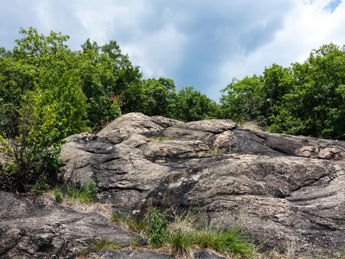
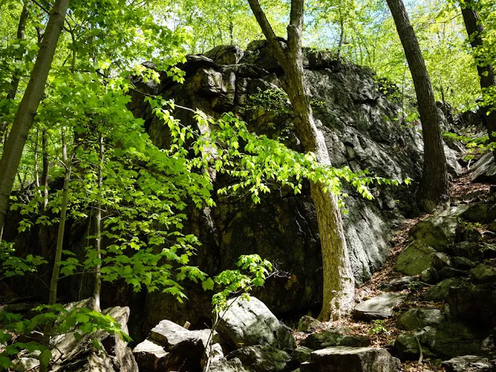
- Rock Climbing Potential: Reviews highlight it as "overall best place to rock climb within 40 miles," indicating its popularity among the climbing community for bouldering and rock climbing opportunities on its exposed rock faces.
- Exceptional Public Transport Accessibility: A significant highlight is its direct access via a "10 min walk from Suffern station" (Metro-North) and a "5 min walk from a commuter lot parking" (Shortline Bus). This makes it highly convenient for city dwellers without cars.
- No Special Equipment Needed (for hiking): For the hike itself, "No special training or equipment is necessary" beyond appropriate hiking footwear, making it approachable for most active individuals.
- Proximity to Stone Memorial Shelter: For those considering overnight hikes, the closest primitive shelter, Stone Memorial, is only about 5 miles from the trailhead, offering a convenient stop for multi-day adventurers.
- Exposed Rock Summit: The top of the mountain is exposed rock, providing an open, natural platform for enjoying the views (though caution is advised during inclement weather).
As a natural hiking area, Nordkop Mountain itself does not offer commercial "promotions" in the traditional sense, such as discounts or sales. Its value comes from its inherent natural beauty and the access it provides to outdoor recreation. However, there are "offers" related to its accessibility and the broader hiking community:
- Free Access to the Trailhead: There is no fee to access the Suffern-Bear Mountain Trail and Nordkop Mountain from the Orange Avenue trailhead. This makes it a free outdoor activity for all.
- Free Commuter Parking Nearby: While there's no dedicated trailhead parking, the availability of "plenty of commuter parking lots within a short walk" that are often free on weekends or after commuter hours, is a valuable benefit.
- Excellent Public Transportation Access: The ability to reach the trailhead via "Metro-North train (10 min walk from Suffern station)" or "Shortline Bus (5 min walk from a commuter lot parking)" is a significant "offer" for New Yorkers without a car, making a challenging mountain hike surprisingly accessible and budget-friendly.
- Inexpensive Trail Maps: "Detailed and inexpensive trail maps can be obtained from New York New Jersey Trail Conference." This is a crucial "offer" as accurate maps are essential for safe and enjoyable hiking, and their affordability ensures everyone can be prepared. Searching for "NYNJCT Harriman" will lead you to these resources.
- Gateway to Harriman State Park: Nordkop serves as an excellent starting point for exploring the wider Harriman State Park system, offering "a few options for overnight hikes" with shelters available. This expanded access to a vast wilderness area is a significant offering.
- Rock Climbing Opportunities: For rock climbers, the presence of climbable faces, recognized as "the best place to rock climb within 40 miles," is a unique and valuable "offer" for the climbing community.
For the most current information on trail conditions, recommended maps, and safety guidelines, it is always best to consult the New York-New Jersey Trail Conference website or the official New York State Parks website for Harriman State Park (as the Suffern-Bear Mountain Trail extends into it).
Nordkop Mountain, as a natural feature and part of a hiking trail system, does not have its own direct contact office or phone number. For information regarding the Suffern-Bear Mountain Trail or the broader Harriman State Park system (into which the trail extends), the relevant entities to contact are:
Primary Resource for Trail Information and Maps: New York-New Jersey Trail Conference
Website: Search for "NYNJCT Harriman" or visit their official site.
General Information for Harriman State Park (which oversees portions of the trail):
Address: New York State Reference Rte 987E, Southfields, NY 10975, USA (Main Park Office/Information for Harriman)
Phone: (845) 947-2444 or (845) 429-8257
For local concerns in Airmont/Suffern, you might contact the Village of Suffern municipal offices, but they typically refer trail-specific questions to park authorities or the Trail Conference.
It is always highly recommended to consult the New York-New Jersey Trail Conference website for detailed, up-to-date trail maps and conditions, and the official New York State Parks website for Harriman State Park for park-wide alerts or regulations.
For New Yorkers seeking a dose of challenging outdoor adventure with a breathtaking payoff, Nordkop Mountain near Suffern is an exceptionally suitable and rewarding destination. Its unique blend of accessibility, challenging terrain, and spectacular views makes it an ideal spot for locals looking to stretch their legs and refresh their perspectives.
One of the most compelling reasons Nordkop Mountain is perfect for locals is its remarkable accessibility via public transportation. The fact that it's just a "10 min walk from Suffern station" (Metro-North) and a "5 min walk from a commuter lot parking" (Shortline Bus) is a game-changer for city dwellers. This eliminates the need for a car, making a vigorous mountain hike a feasible and convenient day trip for millions, promoting an active lifestyle regardless of vehicle ownership.
Furthermore, the hike itself offers a significant challenge that caters to those looking for a robust workout. The "moderate-to-strenuous" ascent, though short, provides a satisfying physical exertion that quickly leads to a truly rewarding experience. The "excellent views of Suffern, nearby hills and highways" from the exposed rock summit are a breathtaking reward, offering a unique blend of natural beauty and a broad perspective of the surrounding region.
For the climbing community, Nordkop's reputation as the "best place to rock climb within 40 miles" makes it an indispensable local resource. This unique feature caters to a niche but dedicated group of outdoor enthusiasts, providing world-class climbing opportunities close to home.
Beyond the immediate challenge, Nordkop Mountain serves as a gateway to the extensive Suffern-Bear Mountain Trail and the vast Harriman State Park. This means that locals can easily transform a short, strenuous hike into a longer adventure, with options for multi-day treks and overnight stays at nearby shelters. This versatility ensures that Nordkop can be a recurring destination, offering new experiences with each visit.
In essence, Nordkop Mountain is more than just a hike; it's an accessible, challenging, and visually stunning outdoor experience that perfectly caters to the adventurous spirit of New Yorkers. It’s a place where you can quickly immerse yourself in nature, push your physical limits, and enjoy panoramic vistas, all within a convenient reach of home.
Nordkop Mountain Photos
Nordkop Mountain Location
Nordkop Mountain
Airmont, NY 10901, USA
 Nordkop Mountain
Airmont
 Brooklands Park
Suffern
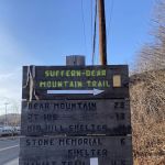 Suffern - Bear Mountain Trailhead
Suffern
 Park
Park57 Washington Ave
 Veterans Memorial Park
20 4th St
 Suffern Village Recreation
61 Washington Ave
 H. Pierson Mapes Flat Rock Park
101 Torne Valley Rd
 William E. Meili Fountain Park
198 Orange Ave
 Riverside Park
Reich Ave
 orchim
115 Franklin Turnpike
 Crowne Plaza Suffern-Mahwah, an IHG Hotel
Three
 Courtyard Mahwah
140 NJ-17
 Clark Recreation Center
59 Campbell Ave
Nordkop Mountain Reviews
This is actually tricky to find, because the gps won’t take you there directly and there’s no sign advertising where to go. Though its the best place to hike in suffern. And overall best place to rock climb with in 40 miles
Oct 11, 2021 · ben peresNordkop Mountain is located near Southwest end of Suffern - Bear Mountain trail (yellow markers).It offers excellent views of Suffern, nearby hills and highways.The trailhead is located on Orange Ave (Rt. 59) and can be reached by a car, Metro-North train (10 min walk from Suffern station) or Shortline Bus (5 min walk from a commuter lot parking). There is no trailhead parking, but plenty of commuter parking lots within a short walk.The climb is moderate-to-strenuous, less than a mile, with about 500 feet ascent, and can be completed in 1-2 hours. No special training or equipment is necessary.The top of the mountain is exposed rock, it’s not recommended to hike there during strong winds or thunderstorms. Also rain, snow or fallen leaves provide an added difficulty due to a slippery rocks.Suffern - Bear Mountain trail doesn’t meet another trail for more than 4 miles, meaning there is no option for a loop hike, only out and back. The entire SBM trail is about 25 miles and technically can be done in a long day, but it’ll be a strenuous hike. There are a few options for overnight hikes, with closest shelter (Stone Memorial) only 5 miles from the trailhead.Detailed and inexpensive trail maps can be obtained from New York New Jersey Trail Conference - local hiking organization. Do a search for “NYNJCT Harriman”
Nov 19, 2018 · Igor O.Great hike, but false address. Search for bear mountain trailhead, right next to finks bar.
Jul 10, 2022 · Eliezer RichelsonCompletely bogus. No trail head at all given the GPS directions everything ends in private drives and private residence
Oct 06, 2021 · Robert BussIt's private property
Jul 21, 2021 · Yehuda Steinmetz
More Scenic Spot
 Brooklands Park4.0 (24 reviews)
Suffern, NY 10901, USA
 Suffern - Bear Mountain Trailhead4.0 (47 reviews)
Suffern, NY 10901, USA
 Park0.0 (0 reviews)
57 Washington Ave, Suffern, NY 10901, USA
 Veterans Memorial Park4.0 (10 reviews)
20 4th St, Hillburn, NY 10931, USA
 Suffern Village Recreation5.0 (4 reviews)
61 Washington Ave, Suffern, NY 10901, USA
 H. Pierson Mapes Flat Rock Park4.0 (42 reviews)
101 Torne Valley Rd, Hillburn, NY 10931, USA
 William E. Meili Fountain Park5.0 (1 reviews)
198 Orange Ave, Suffern, NY 10901, USA
 Riverside Park4.0 (23 reviews)
Reich Ave, Brakeshoe Pl, Mahwah, NJ 07430, USA
 orchim5.0 (1 reviews)
115 Franklin Turnpike, Mahwah, NJ 07430, USA
 Crowne Plaza Suffern-Mahwah, an IHG Hotel4.0 (1538 reviews)
Three, Executive Blvd, Suffern, NY 10901, USA
 Courtyard Mahwah4.0 (813 reviews)
140 NJ-17, Mahwah, NJ 07430, USA
 Clark Recreation Center4.0 (79 reviews)
59 Campbell Ave, Airmont, NY 10901, USA
Categories
Popular Camping Sites
 Coney Island Boardwalk Garden4.0 (75 reviews)
 The William Hotel Midtown, Sonder4.0 (555 reviews)
 Shepard Lake Recreation Area0.0 (0 reviews)
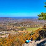 Stairway To Heaven4.0 (185 reviews)
 Howard Bennett Playground4.0 (152 reviews)
 Isle of Meadows4.0 (10 reviews)
Trending Camping Blog Posts
 Top Group Travel Destinations in Europe: Best Places for Group Vacations
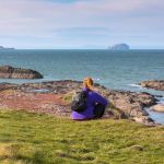 How to Get Involved in Travel Clans for Social Travel: Explore Group Travel Opportunities
 Best Travel Clans for Sustainable Travel
 Best Group Vacation Destinations for Friends: Ultimate Travel Ideas
 Travel Clans for Solo Travelers Looking for Company: Join Unique Travel Communities
 Best Travel Clans for Women Traveling Together